Walk Appeal
From 2013-2015, 1000 Friends engaged in neighborhood-building research and outreach focused on improving the pedestrian experience.
Do you live in a walkable neighborhood? Does your favorite shopping district have good pedestrian infrastructure? What can you, your neighbors, and your community do to improve the public space experience for all?
On this website you can find out more about what makes a walkable street. You can compare your neighborhood or your favorite walk to others, and learn how you can play a part in building a stronger, healthier community by encouraging walking.
Walk Appeal
What makes a neighborhood, a corridor, or a street walkable? Having destinations nearby and in close proximity is important, but it doesn’t tell the whole story. Not all walks of the same distance are of the same quality. How far a pedestrian is willing to walk to and from various destinations, whether a visitor or neighborhood resident, also depends on whether the walk is interesting, safe, and convenient. At 1000 Friends of Wisconsin, we call this idea Walk Appeal. By applying the principles of Walk Appeal to Downtown Madison, Wisconsin, we have gained a better understanding of where Downtown Madison must improve in order to become more pedestrian friendly and accessible and thus improve as a neighborhood.

The essential idea of Walk Appeal is that people will walk a longer distance and enjoy that walk more if the quality of the environment is more conducive to walking. Conversely, if a street environment is hostile to pedestrians, people will be less likely to want to walk more than a short distance. This is the difference between a street that is designed, built, and used as a traffic conveyance device with the pedestrian environment as an afterthought and a street that is designed, built, and used like a quality public space that invites various activities by a broad range of people. Getting more people out into public spaces is one of the keys to creating and sustaining strong communities, and we believe this should include streets as well as plazas, squares, and parks.
Walk Appeal Research and Applications
To analyze the walk appeal of a particular street, we can use both qualitative and quantitative data. Some examples of each type of data are:
Qualitative Data
- Perceptions of safety and comfort
- Sound
- Wayfinding and signage
Quantitative Data
- Street and sidewalk width
- Infrastructure provision and condition
- Pedestrian traffic counts
- Demographic data on event attendees
We also assume that people will walk farther when the walking environment is better. How much farther? Using an assumption from planning and transportation engineering literature that figures on ¼ mile (a 15-ish minute walk) as the standard walking tolerance, we can assign higher tolerances for streets with good walking environments and lower tolerances for those with especially poor environments.
In our first analysis, therefore, we assumed that a quality Main Street (like Madison’s State Street) has a good enough pedestrian environment that someone on foot will walk up to 3/4 mile, while an older urban neighborhood inspires him or her to walk only 1/4 mile. Suburban subdivisions, power centers, and parking-backed thoroughfares provide increasingly negative pedestrian environments and increasingly short walk tolerances. This explains why most people drive from one big box store to the next even if the next store is 300 feet away-not because they don’t want to walk, but because the quality of the walking experience is poor (and possibly dangerous).
These two photos were both taken in Downtown Madison and illustrate the distinctions created with the Walk Appeal concept. One is a typical view of State Street, a classic American Main Street. With historic and interesting buildings, mixed uses, a human scale (buildings generally 2 to 4 stories in height), constantly changing storefronts with window displays, good transit connections, and pedestrian safety features, State Street provides a walking experience that motivates pedestrians to walk around 3/4 mile. In the other, the streetscape as it passes the State of Wisconsin’s agency office buildings is considerably more hostile to pedestrians. Although only 4 blocks from State Street, a pedestrian here would be discouraged from walking more than 1/10 mile.
Using Walk Appeal to Analyze a Commercial Corridor
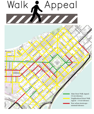
Walk Appeal can be used to analyze the walkability of a neighborhood for various situations and locations with much more complexity and detail than a simple distance calculator like WalkScore can. Below, a hypothetical store on State Street is analyzed by coloring stretches of street with the “Main Street” walking quality green, while streets lined with either urban residential areas or less attractive commercial or institutional uses are colored yellow. Using the 3/4 mile and 1/4 mile tolerances, the business’ ability to draw pedestrian traffic is mapped.
This analysis allowed us to identify gaps in Downtown’s walkability. Obviously, State Street and the Capitol Square provide high-quality walking experiences. However, on West University (1), the Outer Loop (2), and near the Overture Center (3), the pedestrian experience rapidly degrades away from State Street. Improvements in the streetscape could dramatically expand the pedestrian draw of the State Street business.
What, then, would happen to the pedestrian draw of the State Street business if the walkability of these key street areas was improved? The pedestrian-friendly features recently installed on Webster Street (1) have been extended around the entire Outer Loop and part of West Washington, while the other trouble spots, on University Ave and Henry and Dayton Streets, have been similarly eliminated, bringing them into the neighborhood-standard walk appeal category. Additionally, all streets coming off the capitol square have been upgraded to Main Street-standard. The “ped shed” of the business has increased significantly, and walkability gaps have been nearly eliminated. Streetscape improvements can come at the hands of the city (like the outer loop upgrades), but they can also be neighborhood-driven. For example, a public art project can make the streetscape along the blank side walls of larger buildings a more appealing walk, neighbors can sponsor a temporary block party on an underutilized street to call attention to it, a Business Improvement District can help businesses install green roofs or pervious paving, and restaurants can expand their outdoor dining offerings to create a more interactive streetscape.
Other Maps and Online Tools
All streets in our communities should, at the very least, meet the needs of the people who use them. That’s why the most important information on walkability comes from you, residents in communities across Wisconsin. 1000 Friends piloted a couple different techniques for getting on-the-ground, eye-level walkability research.
Eye-Level Walkability Surveys
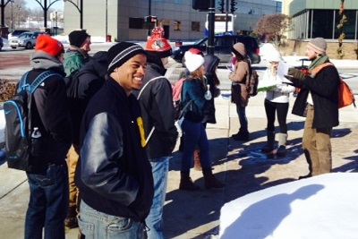
First, we have worked with the Badger Volunteers program in the Morgridge Center for Public Service at the University of Wisconsin-Madison to conduct a walkability survey of Downtown Madison. Twice a week from January through April 2014, several UW students walked up and down the streets of Madison’s central city, taking careful notes on pedestrian infrastructure, conflicts and confusion at intersections, signage, and views and landscaping that make walking more interesting and enjoyable, to name just a few.
These students produced a custom map that displays each point of observation color-coded by category.
 On April 17, 2014, these students will present their work, including their map and their observations, before the Downtown Coordinating Committee, whose purview includes prioritizing public space infrastructure. Madison was beginning the process of developing its first comprehensive Transportation Master Plan, so one of the primary goals of this walkability survey project was to provide a solid basis for pedestrian infrastructure planning and improvement in the downtown area. The other primary goal was to create a template by which other neighborhoods may be surveyed, whether by student volunteers, community members, or other groups.
Download a Walkability Survey template – fill in your own neighborhood streets to start assessing the walking environment.
Online Maps and Tools
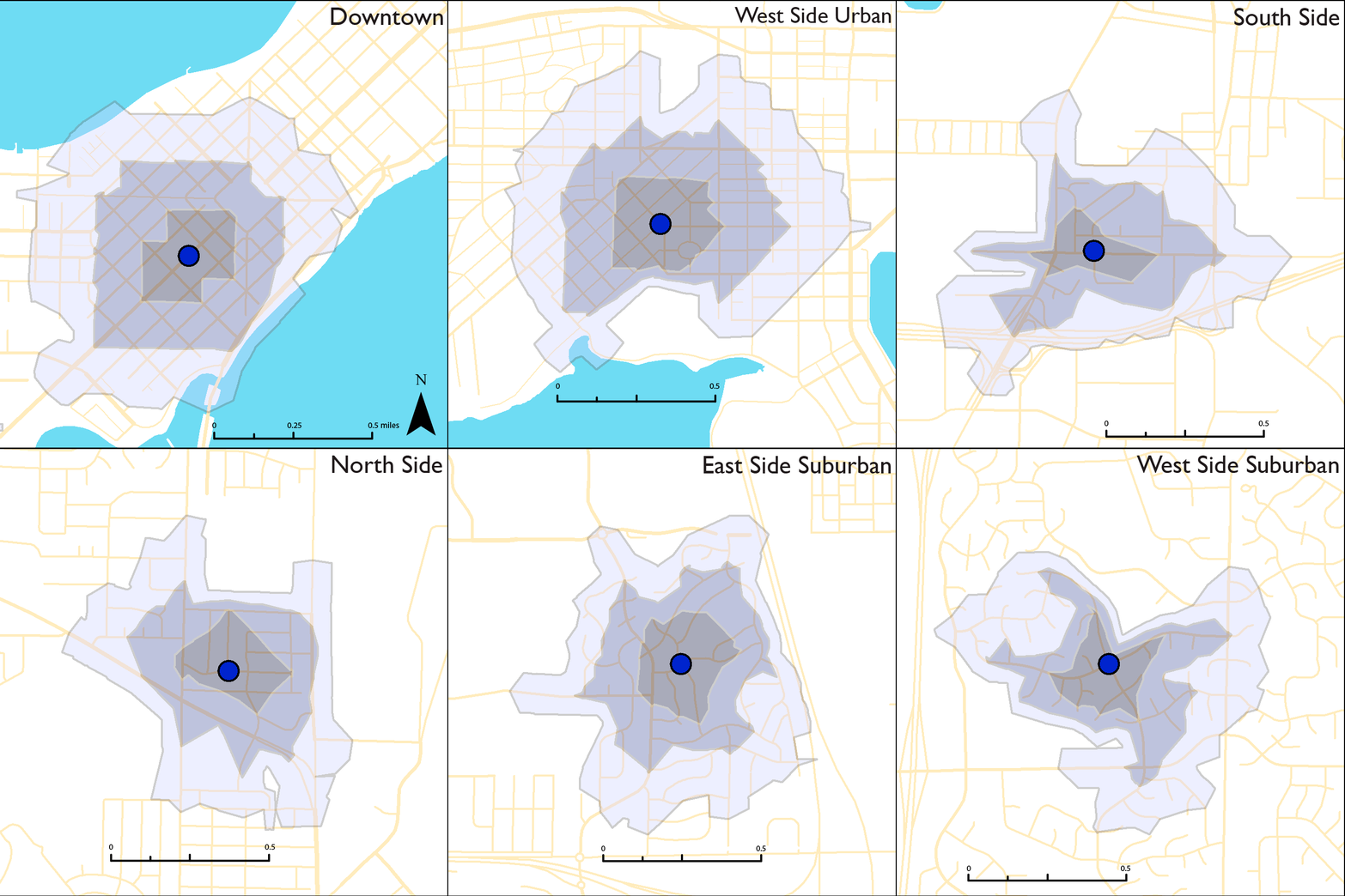
We also worked to create clear, compelling maps and interactive tools that help people understand what makes a walkable street, corridor, neighborhood, and community. For example, we used an analysis of sample neighborhoods in Madison to explain some of the factors that affect walkability.
See how many destinations you can easily reach in this interactive map of Madison. These eight neighborhoods in Madison cover a wide variety of street and development patterns. Scroll over each circle to see which one is most like your neighborhood.
How many places can you walk in 5, 10, or 15 minutes? The answer depends on what neighborhood you’re in! Check out this gif created by Matt.


