Wishing you a healthy and happy holiday season! The Staff and Board of 1000 Friends
Read more about "Happy Holidays"
Wishing you a healthy and happy holiday season! The Staff and Board of 1000 Friends
Read more about "Happy Holidays"
The Kenosha Transportation Academy wrapped up last week with final project presentations held at Carthage College. I’ll be honest, when I started preparation for this Academy, I wasn’t sure how it was going to unfold. Kenosha is bigger and more spread out than any other location where we’ve run this program so far. The city’s […]
Read more about "Final Kenosha Transportation Academy"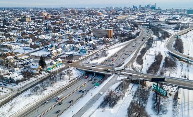
We have joined a lawsuit filed by Midwest Environmental Advocates and Legal Action of Wisconsin challenging federal approval of a $1.75 billion plan to expand I-94 in Milwaukee. The lawsuit alleges transportation officials refused to consider an alternative plan that would have incorporated a public transportation element and fixed safety concerns without expanding the highway. […]
Read more about "Challenging the Expansion of I-94 in Milwaukee"
Join us on Wednesday, December 4 from 12-1 (central) for a webinar with Dr. Wes Marshall, professor at the University of Colorado in Denver and author of Killed by a Traffic Engineer! Killed by a Traffic Engineer was the book of the month for September. Marshall pulls back the glittering green curtain to reveal that […]
Read more about "1k Friends webinar December 4"
On Friday, October 25, members of the Wisconsin Climate Table met in…Illinois?! Yes, that’s right, we met in Illinois. (To be fair, we were within spitting distance of the state line; you could see Wisconsin out the window.) Our fall meeting took place at Nature at the Confluence in South Beloit, IL. Why Beloit? As […]
Read more about "Wisconsin Climate Table fall meeting"
Climate Fast Forward, November 14-15 in Rothschild, WI Join us for Climate Fast Forward 2024, a collaborative climate action conference hosted in Rothschild, Wisconsin, by the Wisconsin Academy of Sciences, Arts & Letters. For the Academy’s third year hosting the event, the conference will now span two days, allowing for more workshops, speakers, and connections than […]
Read more about "Climate Fast Forward 2024"