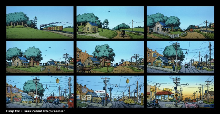
Wisconsin communities have been perpetually changing. Before European settlement, indigenous populations lived in villages with complex trading networks. Early Wisconsin cities were compact centers of commerce. Now we live in sprawling communities supported by massive highway infrastructure. Throughout our history, development has been dictated by our ability to travel. In the era of horse and buggy, long-distance travel was limited and our cities reflected this reality. After trolley cars were introduced, we began to see the first suburbs. Finally, with the completion of the interstate highway system and widespread adoption of the automobile, suburbanization began to flourish.
Our world is largely shaped by the relationship between land use and transportation (the Transportation Connection).
Today, sprawling housing tracts make it largely impossible to access employment, basic goods, or friends and family without a car. As vehicle travel has become more and more mainstream, our land use has responded with big box development, office parks, and abundant parking. At the same time, our regulations have reacted to accommodate cars by building wider streets, and requiring minimum parking requirements, large lot zoning, and unnecessary setbacks.
All of these shifts have created a feedback loop between land use and transportation that further supports automobile dominance.
Unfortunately, in this transition to suburban development, we lost our sense of history and place, all of the things that made Wisconsin communities unique. Our suburban landscapes are identical to thousands of places across America.
Moving forward, special focus should be given to land use that supports transportation alternatives. Outside of select pre-suburban neighborhoods, it is extremely difficult to travel by public transit or by walking and biking. Public transit is infrequent and has limited hours. Sidewalks meander through subdivisions without connecting to meaningful destinations. Bicycle paths often start and stop in a disjointed network that regularly exposes cyclists to dangerous situations with cars. This leaves automobiles as the sole reliable option for travel.
There is good news though, this trend can be reversed by incorporating innovative ideas into our land use decision-making. We need to review our zoning, subdivision regulations, and comprehensive plans to help redefine how our communities develop. We should be focused on building compact, walkable neighborhoods. To create safer, more sustainable places, we have to start building communities that provide residents with meaningful transportation options.
This starts with our land use decisions.
1000 Friends encourages Wisconsin communities to reconsider suburban development patterns and instead redevelop places with existing infrastructure. We advocate for neighborhood designs that are compact and compatible with a range of transportation options. This includes changing zoning, density requirements, and regulations. Changes to local zoning should support mixed-use developments with compact, pedestrian-focused lot sizes.
Our land use decisions and our transportation infrastructure directly impact one another, at times amplifying the faults of the other.
By addressing land use and transportation together we can lower carbon emissions, improve public health, and create more vibrant and livable Wisconsin communities for everyone.
This is the first post in a series highlighting the relationship between land use and transportation – the Transportation Connection – below is a full list of articles in the series.
Part 1: The Connection between Transportation and Land Use
Part 2: Mandatory Parking Minimums
Part 3: Minimum Lot Sizes
Part 4: Local Ordinances (Street Widths)
Part 5: Highways as Land Use

